Why Not Scandinavia?
II - Why Africa and Not Scandinavia?
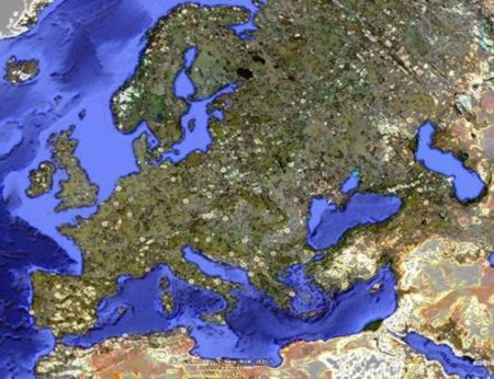
Since Euratlas Periodis is primarily a historical atlas, the maps show the European cultural area. That means we show all the geographic areas that, from the beginning of written records, had an influence on the core area of the European peninsula. Thus, on the fringes, we include the middle Nile valley, the High Atlas mountains, Iran and the Zagros mountains, the upper Volga and southern Scandinavia. We should have included Iceland, the southern Arabian peninsula and Central Asia too, while excluding the central Sahara but such a solution would have caused notable distortions and scale problems.

1) Where are Sweden and the rest of Scandinavia?
The atlas includes southern Norway and southern Sweden, that are the core areas of these countries. Sadly, Iceland, Faroe islands, the Trondheim fjord, and the core area of Finland couldn't be included otherwise the main map would either have excluded Egypt, or have been slanted with the north in the upper left corner, or have been too large to make legible the small states of mainland Europe.
2) Since the atlas is supposed to show Europe, then why isn't Scandinavia in?
The continents are intellectual notions hardly based on physical realities. While it is rather easy to see the difference between the American and Afro-Eurasian landmasses, nobody can tell with accuracy the exact limit between Africa, Europe and Asia. Historically, the Mediterranean Sea is supposed to separate Africa from Europe, but, still it is difficult to know where the islands should be incorporated. Similar problems arise when one wants to trace the separation between Asia and Europe. Nevertheless, our maps are primarily a historical atlas and therefore include the historical areas having influenced the central areas of the European peninsula throughout history.
3) Since you are from Switzerland, which is not part of the European Union, why do you make a map of Europe?
The word Europe designates a continent, a cultural area and a supra-national entity called European Union. In fact, the European cultural area which includes the European peninsula, the shores of the Mediterranean Sea and the western fringes of Asia is one of the regions in the world for which historical sources are most numerous. That is why our atlas is describing it.
4) Since the European Union came into existence thanks to nations like the Netherlands, Belgium, Germany, Scandinavia, Austria and France, why do you include the Southern European states in your atlas?
Euratlas Periodis is not a 21st century political atlas but a historical atlas showing the evolution of a cultural area called Europe. Throughout the said process, several polities have gained some prominence for a while, for instance the Roman Empire in the 1st to 4th centuries, the Holy Roman Empire in the 11th-12th centuries, the Ottoman Empire in the 16th-17th centuries or the European Union in the 21st century. It belongs to historians and commentators to value these facts.
Moreover, we must add that Scandinavia is not a nation, neither modern, nor medieval.
5) Why Scandinavia is not in the maps? Could you remake the atlas to show the rest of Europe also?
Scandinavia proper comprises Norway and Sweden and, usually Denmark is also included since it has the same history and culture.The Euratlas maps are including Denmark in full, southern Norway and southern Sweden, that is the core areas of these countries. Strictly speaking Greenland, Iceland and Finland, are not parts of Scandinavia and we cannot remake the atlas to show these countries.
6) If this is the history of Europe, why do you involve North and West Africa Asia in the atlas?
Europe is not an island. This wide cultural area traces its origins in the valleys of the Tigris, the Euphrates and the Nile. North Africa was one of the richest areas in the Roman Empire, an important state that was encompassing half of the territories of what is called Europe today. Moreover Europe has experienced contacts with other cultures, cultures from West Africa among others, for instance the Almohad Caliphate.
7) What about Scandinavian countries like the Swedish Empire, shouldn’t they have been included as well?
The Kingdom of Sweden or 'Swedish Empire' comprised Sweden, Finland, the Baltic lands, western Pomerania and some lesser territories in Germany during the major part of the 17th century. You can see it on map 1700.
8)Why do you have Egypt and Morocco listed as countries of Europe?
During the Roman times, 1st to 5th century AD, Egypt and the area of modern Morocco were parts of the Roman Empire and the same is true for Syria and Anatolia. Today, in the 21st century, Morocco, Egypt and Syria are considered as countries strongly separated from Europe but who knows what will happen within 200 or 500 years. Our aim is not to say to which cultural area each country should belong to, but to describe the historical evolution of the wide cultural area encompassing the European peninsula and we feel it is worthwhile to know what different cultures are or were present in the core of this area or in its neighbourhood.
See also the article
From Historical Mapping To Historical Geographical
Information System

PDF format
or the presentation

PDF format
Periodical Historical Atlas of Europe
according to your needs